Post by MargaretAnne on Sept 13, 2006 18:13:24 GMT -5
My great-grandfather (my mother's grandfather), owned the Old Head Tide Store in Alna during World War II. My mother and her two sisters used to visit their grandmother and grandfather during summer vacation. They called their grandfather "Papa" and their grandmother "Who-Who" because my mother's older sister called her that as a baby before she learned to talk so the name stuck.
When I asked my mother about it last night, she said that her grandmother played a little game of peek-a-boo with her older sister Jean when she was standing up in her crib. She would peek around the corner and say "Who-Who!" or something like that and that's where the name originated from. I think it's kind of cute.
My mother said that her grandmother always doted on her older sister Jean because she was the first grandchild. At one time, my mother's family and her grandparents shared a two-family home out in the country. "Who-Who" took every opportunity to come to her defense. My grandmother's parents lived in the apartment upstairs and she was always looking out the window while the children were playing outside. She always kept a sharp ear out to any conversation between my grandmother and her children. One day, "Who-Who" asked my grandmother, "Rena, can't you say anything but "No!" to that child?" It was difficult to discipline them when she was listening to every word that passed between them.
"The most interesting and intriguing aspects is that 100 years ago as many as 5000 people were living in Alna,'' he said. "The store was built a little more than 100 years ago primarily because it was a population center. People worked in the mills so it was a great place for a store.''
The person who built the store remains unclear. According to Herz, the store was built by Monarch Roofing. However, Bergman is not exactly sure who built the store.
"At the time the store was being run by Henry Gould,'' Bergman said. "J.A. Jewett was running it by 1894. After that, Lon Jewett and a brother ran the store. After Lon died another man ran the store then it closed after World War II.''
In the last sentence of the above quote, they're speaking of my great-grandfather, Byron Ludwig, but I guess they were unable to find out what his name was at the time this article was written.
wiscassetnewspaper.maine.com/1998-09-24/head_tide_store.html
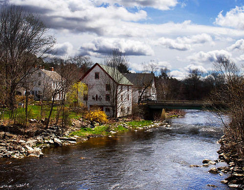
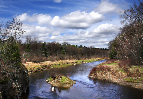
Here are some pictures of Head Tide in the same area where the store was located.

Sheepscot River, Alna, Maine

Sheepscot River, Alna, Maine
www.flickr.com/photos/eva8/137232215/
The village of Head Tide, in Alna, Maine, was the birthplace of poet, Edward Arlington Robinson.
www.earobinson.com/
www.bartleby.com/233/index1.html
Apparently, the Sheepscot Valley Conservation Association moved out of the Old Head Tide Store to a different location as they needed more room.
www.mainelincolncountynews.com/index.cfm?ID=3117
www.sheepscot.org/index.html
Destination 3.
Sheepscot Village and Head Tide
Here is a chance to visit two of Maine's oldest colonial villages. Sheepscot Village, now a part of Newcastle, was founded in the 16th century, by Dutch and English settlers. It is up river from the Georgetown Peninsula on the Sheepscot River. Take a left out of the Inn onto River Road and continue to the right at the fork to Route 1. Travel South on Route 1 a mile or so and take a right onto Sheepscot Road. This will take you through rolling hills and forests into the village of Sheepscot (as you enter the village, the road takes a left turn while North Newcastle Road continues straight). Wander through the village and the old village green. You can take a couple of diversions and bike down King's Highway on your left to view some of the old colonial houses. On the right at the edge of the River, you can take the old bridge over to Dyers Neck Road, and view the old sheep farm and the spectacular views of the Sheepscot River from this vantage point. Continue back onto Sheepscot Road over the River into Alna. At the fork in the road, take the right side which takes you to Route 218. Take a right onto 218 and follow this to Head Tide Road (Route 194) on the right. Follow Head Tide Road into the village of Head Tide. This is the farthest point on the Sheepscot River that the tide is salt water. The old Head Tide Church and the quaint village store are nice stops along the way. You head out of the village on Route 194 South through the rolling hills of Alna to the amazing "Cow Shat Corner." You will know you are there at least a mile before you get there. Take a right onto North Newcastle Road which will take you back to Sheepscot Village and follow the directions in reverse back to the Inn. (Total distance round trip is about 20 miles).
www.newcastleinn.com/itineraries/103.html

Moon over Head Tide Church
www.mainelincolncountynews.com/index.cfm?ID=19831
kennebecjournal.mainetoday.com/news/local/2954841.shtml
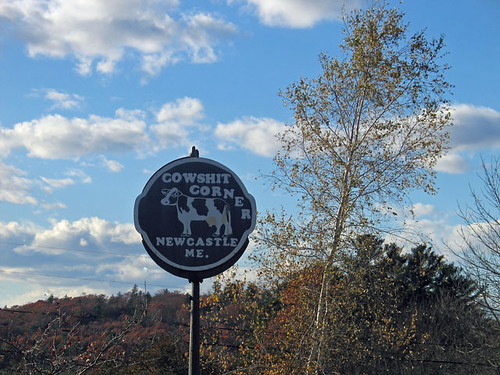
Cow Shat Corner (the forum won't allow me to use that word) is down the road a piece from Head Tide. It's also where my father goes to have his worming hoes made or repaired.

www.flickr.com
I just found a website with more pictures of the "Old Head Tide Store" as well as other places in the village and the Ice Storm of '98.
community.webshots.com/album/132181922HJBXsW
This topic was posted many years ago, so many of the links to articles are not available. That's the problem with posting links that direct the reader to a newspaper article or elsewhere on the web. It would still be worthwhile to visit Head Tide in Alna and all of Lincoln County. It's always much nicer to see it for yourself. Everything the Midcoast region has to offer is right where it's always been, and there are no broken links to prevent us from enjoying it.
At Flickr, if you type Alna, Maine in the search box, it brings up many more photos, but there are proportionately and infinitely more pictures of steam locomotives. Many of them are photos by Kevin Madore. WW&F stands for Wiscasset, Waterville & Farmington Railway. The reference to B&SR stands for Bridgton and Saco River. This is one of the photos by Kevin Madore. His descriptions and photo tags have a lot of detail. Below his description, if you scroll down, there are tags with the abbreviations spelled out.
www.flickr.com/photos/112261457@N06/51637288445/

